
Beyond book looks
Quality assuring the impact of the geography curriculum

When schools review the impact of a curriculum, the conversation often drifts towards the most visible evidence of learning. Book looks, display work, completed tasks and tidy exercise books can all give the impression that a curriculum is working well. Pupils have clearly been busy. Work has been completed. Topics have been covered.
But none of this necessarily tells us what pupils have actually learned geographically.
If quality assurance is going to tell us anything meaningful about the impact of the geography curriculum, it needs to look beyond whether work has been completed and ask a deeper question: what kinds of geographical knowledge are pupils developing?
Thinking about this question becomes easier when we recognise that geographical knowledge does not exist in just one form. It takes different shapes and performs different functions within the discipline.
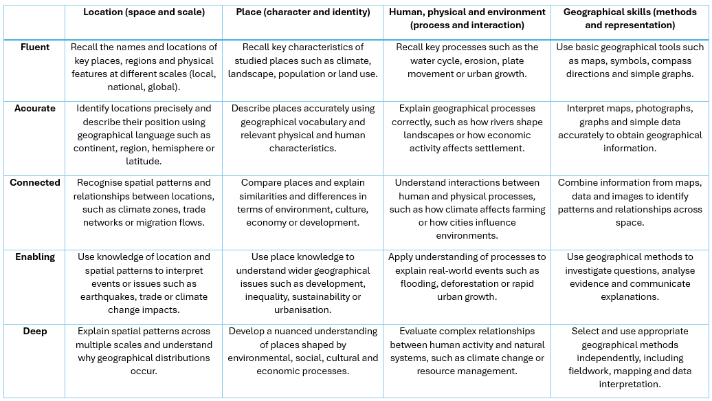
One useful way to think about this is through four broad domains of geographical knowledge:
• Location – understanding space and scale
• Place – understanding the character and identity of places
• Human, physical and environmental processes – understanding systems and interactions
• Geographical methods – using maps, data and fieldwork to investigate the world
Across each of these domains, knowledge can appear in different ways. Pupils may demonstrate fluent knowledge, recalling key locations, processes or characteristics. They may show accurate knowledge, using precise geographical vocabulary or explaining processes correctly. Knowledge can also become connected, where pupils recognise patterns and relationships across space.
In other cases knowledge becomes enabling, allowing pupils to interpret real-world issues such as flooding, climate change or migration. At its richest, geographical knowledge can be deep, bringing together multiple ideas to explain complex spatial patterns or relationships between human activity and natural systems.
These are not stages that pupils climb through one by one. They are different ways knowledge functions within geography, and a strong curriculum will develop all of them.
Looking at impact through different kinds of knowledge
When departments quality assure the curriculum, the focus often rests on coverage. Have pupils studied rivers, climate, cities or trade? Are the planned topics being taught?
While these questions matter, they do not tell us very much about the impact of the curriculum on pupils’ geographical understanding.
Looking instead at the forms of knowledge pupils demonstrate can lead to far richer conversations.
For example, when reviewing pupil work or assessment responses, we might ask:
Are pupils able to recall key locations and processes fluently, or are these ideas still insecure?
Do pupils use accurate geographical language, such as describing locations in terms of continents, regions or latitude?
Do they show connected knowledge, recognising patterns such as climate zones, trade networks or settlement patterns?
Can they use their knowledge in enabling ways, interpreting issues such as earthquakes, urban growth or environmental change?
And occasionally, do we see evidence of deep geographical thinking, where pupils bring together multiple ideas to explain why geographical patterns exist?
This shifts the focus of quality assurance away from presentation and towards the substance of geographical learning.
Using the framework as a quality assurance tool
One practical way departments might do this is by using a simple framework that maps these different forms of knowledge across the four domains of geography: location, place, processes and geographical methods.
A blank version of the table can be used during activities such as book looks, work scrutiny, assessment reviews or lesson visits.
As leaders examine evidence, they can ask which kinds of knowledge are actually visible in pupil work. Are pupils mostly demonstrating fluent recall, for example naming places or listing processes? Or is there also evidence of connected thinking, where pupils recognise relationships between places and processes?
Similarly, the framework can help identify whether pupils are using geographical methods in meaningful ways. Are maps, photographs and graphs being interpreted and analysed, or are they simply being copied into books?
The aim is not to judge lessons against a checklist. Instead, the framework provides a way to structure professional conversations about the impact of the curriculum.
Moving beyond activity towards impact
One of the risks in curriculum quality assurance is that we focus too heavily on what teachers are doing rather than what pupils are learning.
Lessons can be engaging, resources well designed and books beautifully presented while the geographical thinking remains relatively shallow.
Looking at the different forms of geographical knowledge pupils demonstrate helps shift that conversation. It encourages us to ask not simply whether pupils have studied rivers or cities, but whether they are beginning to think geographically about the world.
Do they recognise spatial patterns?
Can they explain why places are the way they are?
Are they able to use maps, data and fieldwork evidence to interpret the world around them?
These questions tell us far more about the impact of the curriculum than any number of completed worksheets.
Seeing the curriculum through the lens of geographical knowledge
Ultimately, quality assuring the geography curriculum is not about checking whether the planned content has been delivered. It is about understanding whether the curriculum is helping pupils develop increasingly powerful ways of thinking about the world.
By looking at the different ways geographical knowledge appears in pupil work – fluent, accurate, connected, enabling and deep – departments can gain a much clearer sense of how learning is developing.
The result is a more meaningful conversation about curriculum impact.
Not just whether geography is being taught, but whether pupils are actually learning to see the world geographically.